Monday, February 22, 2010

Back to the High Country - Paddy's River Dam, Free Pet Friendly Campsite


I had commitments Sunday morning so we couldn't camp overnight Saturday night, but we went for a bit of a drive.  I had had a particularly 'average' week at work so we decided the best cure is go bush!

We hit the highway heading south with lunch and snacks, and no real plan.  We went south to Tarcutta, NSW where the trucker memorial wall is located.  Tarcutta is near enough to halfway between Sydney and Melbourne on the Hume Highway so it is a fitting location for a memorial for the truckers killed on the job.  If you are a regular traveler on Australia's major highways, you will no doubt have a great deal of respect for the professional drivers who haul the stuff that we eat, drink, read, play with...  If you are passing through Tarcutta stop and pay your respects, we did.  If you are not down this way - http://www.tarcuttamemorial.com/ will get you there.

We turned off the highway and drove across to the small town of Tumbarumba.  Established on the site of a Hume and Hovell camp, it was originally a gold mining town, now a Snowy Hydro town and hub town for the local agricultural industries.

Turning north out of town we headed into Bago State Forest.

 
Brumbies and foal

As soon as you see brumbies you can be assured you are in for a nice trip.

  It wasn't long before we arrived at the dam and campsite.  I should point out that there is a creek crossing on the way in to the dam camping area.  My standard 4WD did it easily.  It would be wise to check depth after rain and during snow melts.

The campsites are basic, there are firepits, some toilets and picnic tables.  That said it is high country bush camping paradise.


 Idyllic really isn't it?


Rustic mountain loo

We left the area thinking that a return visit would be worthwhile!

We left intending to head for home but as happens we saw a sign indicating we were 10km from a waterfall - so off we went.


Part of the falls


And the view

We decided to head out of the mountains - via Talbingo and past  Tumut No 3 power station.


There is water in the pipes,
being turn into electricity

OK - some camping stuff...
Access:  Sites at Paddy's River Dam are 4WD access due to the river crossing.
Toilets: Some - long drop.
Showers: No.
Water: No - treat dam water before drinking.
Shop: No - drive to Talbingo or Batlow.
Campfires: Yes - subject to firebans.
Pets: Yes - No posted restrictions
Cost: Free.
GPS: 35 42.9759S 148 10.0049E


Sunday, February 14, 2010

Australia Day Weekend - Part 3 - Willis, Victoria to Dalgety

This will be the final real installment of this camping trip.  As I write this it is a dark and rainy morning in Yass, and yesterday was a dark and rainy day as well.  We spent the day away from home yesterday, at the Queanbeyan 4WD Spectacular.  We arrived before the rain set in proper and were able to have a good look around.

Enjoyed it immensely - kudos to the organisers for a job well done.

As our broken tent had thrown what passes for planning out the window we had a swim in the 'mighty' Snowy River after we had set up the campsite and over dinner we had a talk about the plans for the next day.  After a bit of trolling through the maps and guidebooks we decided that we would head to Seldom Seen, the Mackillop's Bridge and Delegate River where we would leave the dirt and Victoria, for the drive to Dalgety, where we wanted to go Platypus spotting.

The maps showed a place called Suggan Buggan as the first town we would pass through and they indicated that there is an historical school house in town.  The history surrounding the school is a bit foggy in my mind, but it seems that the schoolhouse was built by the station owner Edward O'Rourke in 1865.  O'Rourke apparently had 13 children!

The school is worth a look, and the apples for sale in bags, hanging on the fence were great.  However that was the only thing for sale in Suggan Bugan.

 
Exterior of the historic school

There is camping at Suggan Buggan on the river.  It looked like there were toilets at the site as we drove by.

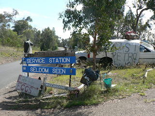
We hit the tar briefly south of Suggan Buggan as we headed for the Seldom Seen Roadhouse - which we have now seen!

The Seldom Seen Roadhouse fell victim to the 2003 bushfies, and the business was burned to the ground!  The owner and his dog survived by taking shelter in the dam.  He has since rebuilt.  We chatted briefly as the cats, dogs and chooks wandered about.


The driveway


The servo

This is a fairly remote and wild part of the country, and for the business to survive is a testament to the owner.  If you are down this way help him out - buy some fuel or supplies from him.

We then headed back north and turned east, off the bitumen again heading past Little River Falls, which were rather dry, and then on to McKillop's Bridge.  The road through here, while surrounded by spectacular view, is described on the Parks Victoria website as 'one of Victoria's most precarious roads...' and I agree.


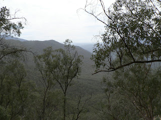
The view

I haven't got a photo that gets the idea across, but the road between Little River Gorge and MacKillop's Bridge is signposted as being unsuitable for semi-trailers and caravans.  If you are towing a camper trailer you may have difficulties if you meet an oncoming vehicle as you may have to reverse a considerable distance to a spot where passing is possible.

Little River Gorge is, I'm told, the deepest gorge in Victoria.  The road is very close to it and in places single lane, with no guards.  If it is wet I would avoid traveling here.

 With the most precarious road out of the way we came to MacKillop's Bridge.  It is a pretty cool bridge, being about 250m long and about 20m above the waterline of the Snowy River it must have been a feat of engineering to get it built.  Actually, it was a feat, the first bridge was 15m above the waterline, and when the Deddick River flooded a few days before the official opening, and the bridge was destroyed.

The area is renowned for it's silver mine, interesting bush walks and 4WD tracks, so again I think worth a return trip.


Approaching the bridge
 
 
Crossing the bridge

In a fairly short period of time the road improved markedly...

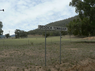
We passed through Deddick township ...


That's about it

  We followed the Deddick River cross country until we joined the main road which took us back to NSW and then up to the township of Dalgety.

We intended visiting friends in Dalgety, but when they were not home we decided to set up at the local caravan park. I have decided against 'reviewing' caravan parks, but this one was cheap, cheerful and after a quick dip in the Snowy River we were more than happy to make use of the shower block.  After three days without a shower we were fairly keen for a bit of a clean up.


And a cuppa

Kudos to the chaps in the Dalgety pub who fed and watered us that night while we waited for our friends to return.

When they did they took us to the Snowy River and we spotted the elusive Platypus, just on dusk.

The next morning we had a fairly standard pack up the gear and head for home.  This time it was a drive up the Monaro Highway, through Cooma, Canberra and then on to Yass.

So there in a nutshell is the way we spent Australia Day and the few days before it.

Saturday, February 6, 2010

Australia Day Weekend - Part 2 - Three Mile Dam to Willis, Victoria

Spending the night in the broken tent wasn't as bad as we thought, but during the evening at Three Mile Dam we decided that we should go to a camping store and either replace the broken part or buy a new tent.  Before we did that we wanted to head to Cabramurra, the highest town in Australia.

We set off through the Mt Selwyn snowfields, which looked to be pretty much deserted as we drove through, and onto a well maintained gravel road to 'shortcut' to Caramurra.  Shortly we arrived in the country's highest permanently settled township.  There are limited supplies available here, such as fuel, a small general store etc.  The were all shut - it was early on a Sunday morning.  There are some amazing photos of the Snowy Mountains Scheme in the General Store.  It is definitely worth a look if you are in the area.


It's a pretty place
Cabramurra from the lookout

After a brief look through the town we decided to head for Jindabyne.  This meant a cross country run to Khancobin and then along the Alpine Way and passing through Thredbo.  It's a sealed road most of the way but there are some steep climbs as you go along.  You get to see a fair bit of the infrastructure that is the Snowy Mountains Scheme on the drive from Cabramurra the Thredbo side of Khancobin.  There are dams, ponds, spillways, pipework and things that look like spaceships that make up the scheme.  We stopped at Khancobin for a some morning tea and then headed along the Alpine Way.

We ventured into the Geehi campsite on the way in.  It is a free camp once you pay the relevant National Park use fee.  There are toilets and water available and there are no marked sites.  Your campsite will be located alongside the delightfully named Swampy Plains River.

Moving on we the visited the Tom Groggin campsite, a little closer to Thredbo.  It's on the banks of the Murray River and has toilets, water and fire pits.  If you are in a 4WD you can ford the Murray into Victoria and visit some fairly remote high country along the Davies Plain Track to the Davies Plain Hut.


The mighty Murray River
at Tom Groggin

We then continued on though Thredbo and into Jindabyne where we had a couple of calls to make, and some business to do before a fairly high speed (relatively speaking) drive into Cooma where we replaced the tent then returned to Jindabyne to set off for the next part of the trip.
Our original plan was to drive to Buchan Caves.  The time we took to replace the tent ruled this out so we didn't really have a plan.  I had read about the Customs station that once existed on the New South Wales - Victoria border so we set out for the campsite nearby.

To get there we turned onto Barry Way and set off.  This road is amazing and if you get the opportunity to drive it, do it in the dry - it would be extremely slipper when wet, and take lots of photos.  It is definitely worth a stop at the Wallace Craigie Lookout.


The lookout

The lookout has some informative boards that describe the Snowy River and the bushfires that burnt though the area in 2003.  There are also toilets there.


View from the lookout

The road from there continues down to the Snowy River and you follow it right down to the border.  It is suitable for 2WD vehicles but caution would be advisable.  It is fairly narrow and at times there are some steep and deep dropoffs.

In NSW there are many little campsites between Barry Way and the River.  Some have toilets, most don't.  Most appeared to be fairly small, suitable for a couple of tents.

Continuing on we eventually hit the border...


The border crossing at Willis
 
It is actually not far from the border at Willis, NSW to the campsite at Willis, Vic

The campsite at Willis, Vic is a bit place with toilets only.  The campsites are located on the banks of the old 'mighty' Snowy River, not the edge of the current Snowy River, which receives about 1% of it's original flow.

We set up camp in the dedicated school group are - school holidays were still on so we thought we would be safe.

 
Our campsite


Road in the campground


The Snowy River at Willis Campground


Fire pit at Willis.

OK - some camping stuff...
Access:  Willis is 2WD accessible.
Toilets: Long drop.
Showers: No.
Water: No.
Shop: No - drive to Jindabyne in NSWor Seldom Seen in Vic (limited supplies.)
Campfires: Yes - subject to firebans.
Pets: Nope - Parks Victora
Cost: Free.
GPS: Latitude 36° 53′ 18.852"S Longitude 148° 25′ 17.832"E

The third day will be the trip from Willis along the Deddick Track to Dalgety in NSW.  I'll get to that soon!